Remote Sensing of Ground Water:
Calibration of Environmental Ground-Water Flow Models to Satellite Data
Matthew W. Becker, Ph.D.,
Department of Geology,
Funded by the the NASA
New Investigator Program
Ground water is the last component of the hydrologic cycle to receive the benefits of remote sensing. A few efforts have shown, however, that vegetation, snow, or thermal anomalies on satellite images can indicate areas of shallow ground-water and/or ground-water discharge. The proposed project will refine and ground-truth these methods, and demonstrate how satellite data can be used to calibrate ground-water flow simulations for the purpose of regional-scale environmental modeling. Images acquired by the new ASTER instrument will be emphasized because of ASTER's ability to collect data in the visible to thermal infrared spectra, separate surface temperature from emissivity, image at day or night, and acquire digital elevation data. Ground surveys and instrumentation of three field sites will verify satellite observations and enable physically-based modeling of thermal anomalies, which has been neglected in previous studies. The project will be leveraged by an existing grant to build a GIS-interfaced high-performance analytic element model (AEM) of the primary field site, which is particularly well-suited to integrating and manipulating disparate forms of data derived from hydrologic and remote sensing investigations. The final product will be a remote-sensing based spatial decision support system for ground-water and ecosystem protection. Research will be integrated into classroom, computer laboratory, and field curricula that combine local hydrogeology with remote sensing. An interactive web tool will overlay remote sensing images and hydrologic data onto a 3-D topographic object, that depicts watersheds in the context of the regional earth system. These activities mesh well with existing efforts of the University at Buffalo Geology department, where remote sensing research is already being conducted by half the faculty.
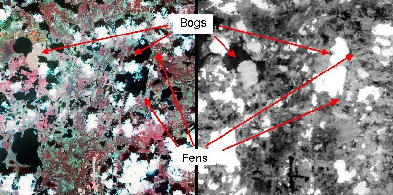
Shown below are portions of two ASTER images take over the Trout Lake Long Term Ecological Research (LTER) Site in Northern Wisconsin. On the left is a daytime image (RGB bands 321), taken at about noon on May 13, 2000. On the right is a night time thermal image (band 10), taken at about 11 pm, on October 11, 2000. Brighter greyshade represents warmer regions in the thermal image, darker greyshades represent cooler areas. Note the difference in lake temperature in the area due, primarily, to differences in lake depth. Note also how much are the bogs (wetlands disconnected from ground water) than the fens (wetlands connected to ground water). These thermal difference may be due, in part, to the flow through of ground water that keeps the wetland warmer in cooler weather.