
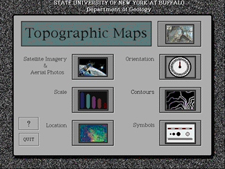
The Topographic Maps Module discusses topics such as Orienteering, Satellite Photos & Aerial Imagery, Scale, Location, Symbols, and Contours. It includes an interactive exercise in Orienteering, and is an excellent introduction to topographic maps for undergraduates.
![]()
Here's a ScreenShot of the Main Menu:
![]()
IMPORTANT! To Download,
Option-Click on one of the "Get It" links below to save a copy of the module
on your computer via our FTP site.
![]()
| Use the Topographic Maps Module through your browser via the Roadster Plugin. (8.5MB) | |||
| Download the Topographic Maps Application for Macintosh or Power Macintosh computers. (3.5MB) |