You will import some data from a New York State data source and reproject it to match a Digital Image (GeoTiff) and a printed Quad Map.
Prepare a directory in your class directory, called map_proj. Create subdirectories called "data", "shapefiles", and "rasterfiles".
Go to the Cornell University Geospatial Information Repository (CUGIR) Site. This site (pronounce cougar) is extremely useful for FREE NYS GIS data. On the left, you will see a number of options for entering the site. Choose Browse by List, and search for Roads in Cattaraugus County. You will see several sources of Road data. Look at the Metadata for the Roads shapefile (009rds.tar.gz). Read down through the metadata file and you will find that it is organized into:
You will see that the projection information is under "Spatial Reference Information".
Save this html to your data directory for later reference. You can do this in Netscape by right clicking on the text area, open frame in a the current window or new window, and then save the file as html. Now download the roads 009rds.tar.gz into your data directory.
Repeat this process to find save the hydrography data (009hys.tar.gz) and metadata to your data directory.
If for some reason the CUGIR site is down, you may retrieve the data from the class ftp directory.
Unzip and untar the files. Rename the shapefiles to "hydro" and "roads".
You will cover the same area around Machias that you used in a previous exercise, but will work with an actual Geotiff file. You will find the file delevan_geotiff.tar.gz in the class directory in the folder "map_project" or the ftp directory. Copy or download the file (this may take a while it is BIG) and expand it into your your data directory.
Start ArcView and set the working directory to your shapefiles directory. Save the project as map_proj.apr. Create a new view, and add the hydro and road shapefiles to the view. Change the colors etc so that the roads and streams are distinguishable.
If you move the cursor around the maps you will notice that the coordinates given are in decimal degrees. The shapefiles have not yet been projected. The metadata told us as such:
Rename the current view to Geographic Coordinates.
Add the Geotiff image to the view and activate it. Click on Zoom to Extent of All Themes. You probably won't see anything. To see why look at the coordinate system, which now gives coordinate values much larger. This is because ArcView is now trying to display the thems in decimal degrees (~42 lat -78 long) and the UTM coordinates of the Geotiff (~4,700,000, 705,000). Verify this by activating the Geotiff only and clicking "Zoom to Active Theme" and then activating a shapefile and clicking "Zoom to Active Theme".
Activate the Sample Extensions Browser, and then the Projector! Extension as you did in the previous ESRI lesson.
To find out what projection the Geotiff data are in, you need to look in the metadata "header" file that comes with the Geotiff file. If you open DelevanSW.hdr in your favorite text viewer you will see the following:
FILENAME: 42078D48
QUADRANGLE_NAME: DELEVAN
QUADRANT: SW
WEST_LONGITUDE: -78 30 0.00000
EAST_LONGITUDE: -78 26 15.00000
NORTH_LATITUDE: 42 26 15.00000
SOUTH_LATITUDE: 42 22 30.00000
PRODUCTION_DATE: 1997 12 19
RASTER_ORDER: LEFT_RIGHT/TOP_BOTTOM
BAND_ORGANIZATION: BIP
BAND_CONTENT: RED
BAND_CONTENT: GREEN
BAND_CONTENT: BLUE
BITS_PER_PIXEL: 8
SAMPLES_AND_LINES: 5983 7713
HORIZONTAL_DATUM: NAD83
HORIZONTAL_COORDINATE_SYSTEM: UTM
COORDINATE_ZONE: 17
HORIZONTAL_UNITS: METERS
HORIZONTAL_RESOLUTION: 1.00000
SECONDARY_HORIZONTAL_DATUM: NAD27
XY_ORIGIN: 705320.00000 4701848.00000
SECONDARY_XY_ORIGIN: 705304.82700 4701626.23300
NATION: US
STATE: NY
NW_QUAD_CORNER_XY: 705625.72500 4701381.34400
NE_QUAD_CORNER_XY: 710766.67500 4701534.70200
SE_QUAD_CORNERY_XY: 710976.14700 4694594.26700
SW_QUAD_CORNER_XY: 705830.08000 4694440.94000
SECONDARY_NW_QUAD_XY: 705631.45200 4701167.22900
SECONDARY_NE_QUAD_XY: 710772.54500 4701320.59100
SECONDARY_SE_QUAD_XY: 710982.01500 4694380.24700
SECONDARY_SW_QUAD_XY: 705835.80400 4694226.91500
RMSE_XY: 3.90000
IMAGE_SOURCE: COLOR INFRA-RED FILM
SOURCE_IMAGE_ID: NAPP 8066-002
SOURCE_IMAGE_DATE: 1995 3 28
SOURCE_DEM_DATE: 1996 1 1
AGENCY: WESTERN MAPPING CENTER (WMC)
PRODUCER: WOOLPERT LLP
PRODUCTION_SYSTEM: INTERGRAPH ISPM, ISIR
COMPRESSION: UNDEFINED
STANDARD_VERSION: 1996 12
METADATA_DATE: 1998 1 9
DATA_FILE_SIZE: 138458586
BYTE_COUNT: 17949
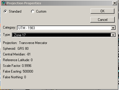
This file tells you that the Geotiff is projected in UTM Zone 17 coordinates, using the NAD83 datum. We will use the Projector! Utility to convert the unprojected shapefiles to UTM Zone 17 coordinates. Activate the Roads shapefile and click on the Projector! icon. Choose meters as the units and then UTM-1983 and Zone17.
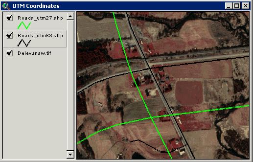
Let the utility recalculate areas and perimeters and save the shapefile as "roads_utm83.shp" and display it in new view. Rename the view "UTM Coordinates". Add the Geotiff to the View (make sure you activate the Geotiff Extension). Activate the roads and the Geotiff (make sure the Geotiff theme is below the roads theme so you can see the roads). Now you should be able to see both the Geotiff and the shapefiles on the screen. The roads on the Geotiff and shapefiles should map well, but not perfectly. There are some distortions in the Geotiff file and encoding distortions in the shapefiles. You will see in some places the match is nearly perfect, and in others not entirely perfect.
As a comparison, project the roads shapefile again into UTM Zone 17 cooridnates but use the NAD27 datum. Save the projected shapefile as "roads_utm27.shp". Add the new theme to your UTM Coordinates View. Activate both the roads_utm27.shp and roads_utm83.shp themes. Note the difference in the position of the roads due to the change in datum. Use your measurement tool to measure the difference in meters between the two projections. It should be considerable!
Now repreat the projection process that you used for the roads shapefile, for the streams shapefile. Check the UTM 83 projection against the Geotiff to make sure it looks right. You will also need a UTM 27 projected version of the stream files.
Change the attributes and titles of your themes to readible and distinguishable form.
The data have already been projected into UTM coordinates, but you may want to convert that projection to another, for some purposes. We will convert the data from UTM to New York State Plane Coordinates, West Zone.
Use the Projector! Utility to convert the Roads UTM-27 Shape file. The process is the same as your original project, except that you must specify the initial projection of the theme. Choose State Plane -1927 as the Category, and New York, West as the type. Add the new re-projected shapefile to a New View. Rename the new view "New York State Plane Cooridinates".
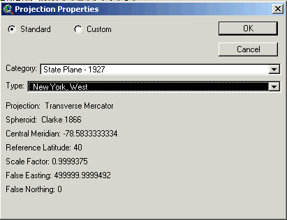
If you look at the coordinates as you browse through the window you will see they are quite different than the UTM coordiates, but are a planar X,Y projection system.
Repeat this re-projection process with the Streams UTM 27 shapefile.
Confirm You Projections with a Paper Map:
Confirm your UTM and State Plane Projections by picking two points on the provided Quad maps. These maps are from the Department of Transportation (DOT) but are based on the USGS Quad (1:24,000) map and have the same coordinates.
You will notice at the center bottom of the map that information is given on the various tick marks. Find two points on the quad represented by the intersection of roads. Measure their location as accurately as possible in both UTM and State Plane coordinates. Compare these coordinates with coordinates obtained from your two ArcView projections for these same points.
Prepare a 2-map layout that shows the comparison of these match points for both projections. Manually set the scale of both map so that they are at the same scale. You can do this by typing in a scale in the upper right hand corner of your working view. Display both streams and roads on both maps.
Label the names of the roads that form the intersection using the label tool (note that road names are given in the attribute table). Provide a text graphic that indicates the actual measured coordinates of your two points. Make sure you clearly indicate the projection of your each map, including the datum used. Use the descriptions shown on the Quad map as a guide.
As always, you will be graded on the clarity of your map. Make it look nice!