Laboratory 7 - The Third Dimension I
i. Motivation. Earth science information is conveyed not only in planform (map) views, but also in three-dimensions. This is perhaps the most difficult aspect of the science to grow accustomed to. Because the vertical heterogeneities in geological materials and properties are as strong as the horizontal, an ability to manipulate three-dimensional information is essential.
ii. Reading.
See course outline, and read this extract:
"COVERED LACCOLITHS. In the northern Black Hills region several prominent domes in the sedimentary rocks probably indicate the presence of laccoliths underground. No igneous rocks appear, but as the dome structure is precisely similar to that in uplifts in which erosion has exposed the igneous core, it is difficult to ascribe them to any other cause. One of the most marked examples is the well-known Green Mountain, or "Little Sundance Hill," shown in Plate XVIII. This dome rises out of the middle of the Red Valley a short distance east of Sundance and is beautifully symmetrical, with dips of 8° to 10° on its flanks. The greater portion of its slope consists of Minnekahta limestone, but in the center the upper sandstone of the Minnelusa is exposed. A smaller outer encircling ridge due to the lower gypsum bed in the Spearfish formation is a notable feature. A similar but smaller dome known as Lime Buttes rising out of the Red Valley 6 miles southwest of Green Mountain presents only the Minnekahta limestone; another, Gypsum Buttes, 2 miles farther south, consists entirely of gypsum."
-- from: Geological Survey Professional Paper 65. Geology and Water Resources of the Northern Portion of the Black Hills and Adjoining Regions in South Dakota and Wyoming
iii. Review concepts.
Structures, stratigraphy
iv. New concepts.
Stratigraphic
columns, cliff forming and slope forming units
v. Exercises.
1. You are an oil-company geologist assigned
to make a reconnaissance geological map of Green Mountain, Crook County, Wyoming (Fig. 1; UI
stereogram #172), to determine if there are any potential oil traps.
A. Read the above extract from Professional Paper 65 carefully.
B. On a tracing paper overlay of the stereogram, map geologic units
based on the outcrop pattern seen in the slopes around the edge of the
mesa, the topographic map, and your general information that the
resistant Minnekahta Limestone comprises the outer cuestas of Green
Mountain, with the less-resistant Minnelusa Formation in the interior.
Exterior to the Minnekahta LS is the mostly slope-forming Spearfish
Formation. Look at whether each unit is 'slope-forming' or
'cliff-forming.' Map only for the part of the photos that is
stereoscopic.
C. On the overlay, map prominent marker horizons in
the Spearfish and Minnelusa Formations, in particular, the "lower
gypsum bed in the Spearfish Formation".
D. There is a structure in the area; mark it with correct symbology.
E. Label units and make a legend.
Figure 1. Green Mountain, WY, topographic map. View Green Mountain in a larger map.
2. For the map units shown in the map of a portion of Grand Canyon National Park (Ap2-12,13; Fig. 2), construct a stratigraphic column (Fig. 3). Remember, stratigraphic columns show not only the rock units and their thicknesses, but also unconformities and the relative weathering of the units.
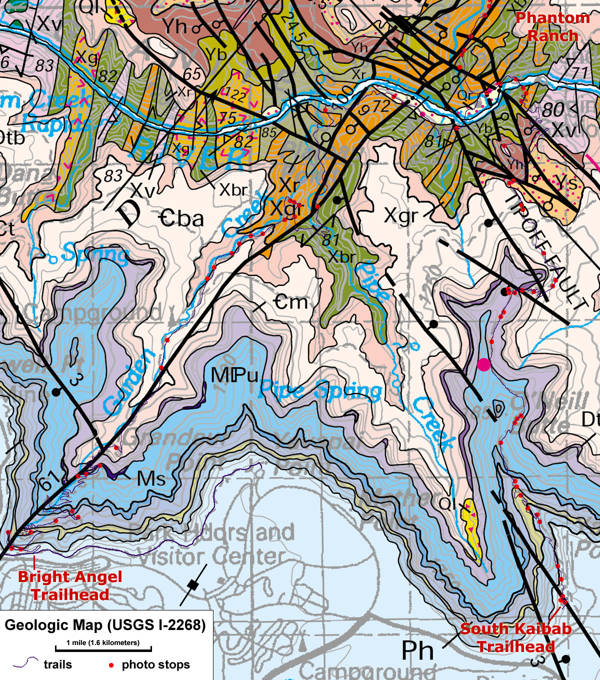
Figure 2. Expanded view of Grand Canyon geologic map.
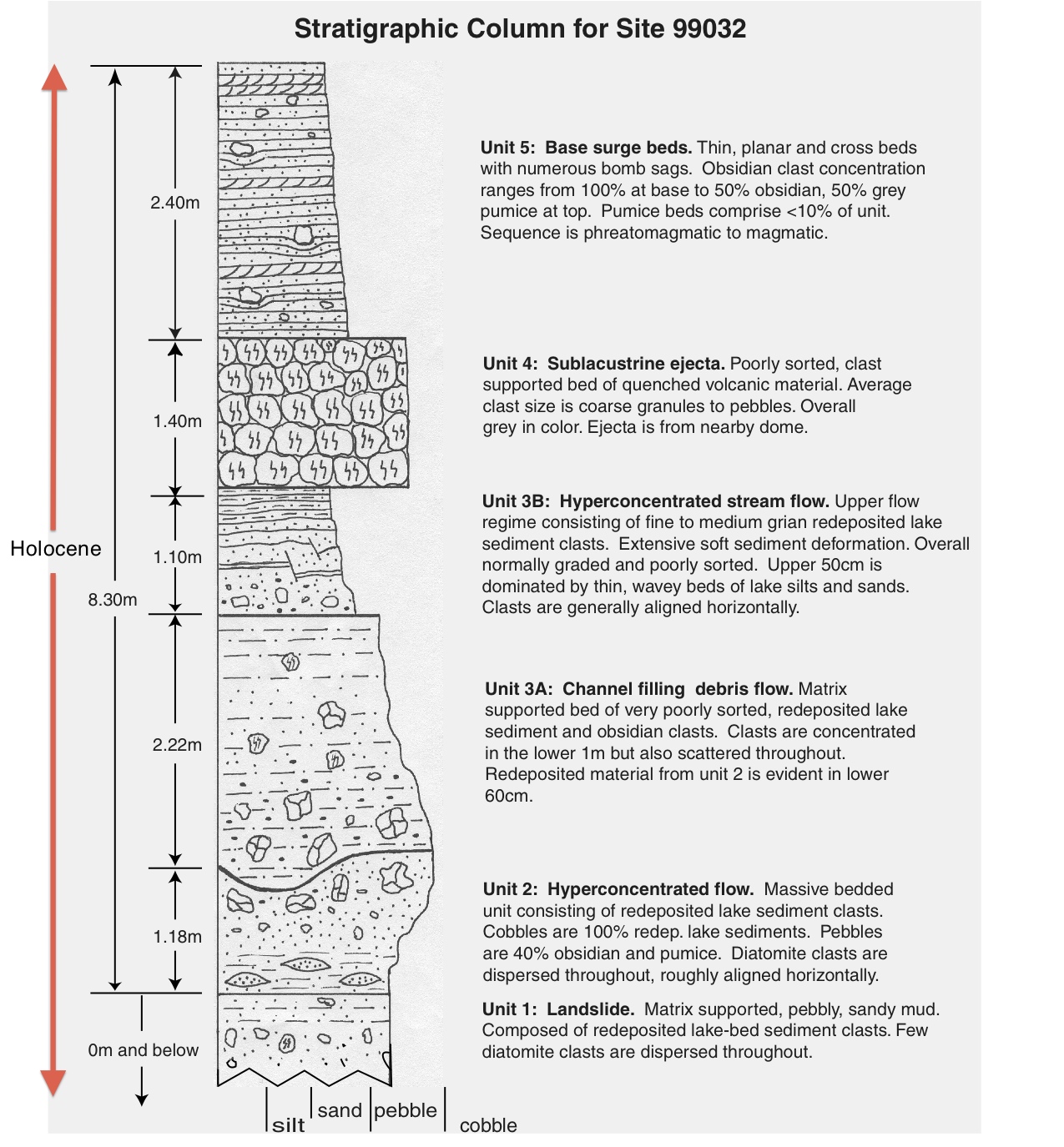
Figure 3. An example of a stratigraphic column.