Eventually the rocks are so stretched out of shape that they cannot bear the stress any longer. The fault slips, and the stage is set for the next cycle of strain buildup and release.
Steven Dutch, Natural and Applied Sciences, University of Wisconsin - Green Bay
First-time Visitors: Please visit Site
Map and Disclaimer. Use "Back" to return here.
Greatest Earthquakes and Volcanic Eruptions
Most Quakes Occur along Faults (Fractures in Earth's Crust)
|
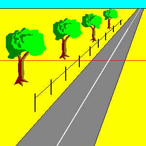
Here we have a landscape with a road, a
fence, and a line of trees crossing a fault. As the crust
moves, the rocks adjacent to the fault are deformed out
of shape (in reality the deformation is spread across
many kilometers - if it were this obvious, earthquake
prediction would be easy). Eventually the rocks are so stretched out of shape that they cannot bear the stress any longer. The fault slips, and the stage is set for the next cycle of strain buildup and release. |


 |
|
Nappes or Overthrusts are shallowly-dipping thrust faults found in almost all mountain ranges. Because they are nearly horizontal, they often have very complex outcrop patterns.
 |
A Window (W) is an opening where erosion cuts through a shallowly-dipping thrust fault to expose the rocks below. A klippe (K) is an isolated remnant of a thrust fault block. |
Ideally, we'd like to be able to hover above the earth during and earthquake and watch the earth move beneath us. Since my anti-gravity belt is in the shop for repairs, the closest we can come is with a pendulum.
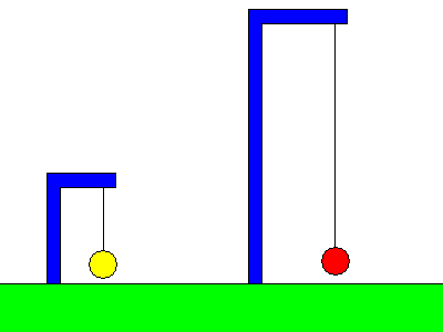 |
Contrary to intuition, an earthquake does
not make the pendulum swing. Instead, the pendulum
remains fixed as the ground moves beneath it. A pendulum with a short period (left) moves along with the support and registers no motion. A pendulum with a long period (right) tends to remain in place while the support moves. The boundary between the two types of behavior is the natural period of the pendulum. Only motions faster than the natural period will be detected; any motion slower will not. |
Since earthquake vibrations can have periods of many seconds, we need a pendulum with a very long period. We can construct a pendulum with a very long arm, or we can build a compact instrument by building a horizontal pendulum. If the pendulum is built like a swinging gate, the restoring force (force pulling it back toward the center of its swing) can be made very weak, and the pendulum can have a period as long as we like.
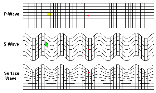
Seismic waves come in several types as shown below:
We can plot earthquake intensity by gathering reports from observers. Although the reports will be subjective, and vary somewhat, most observers will agree on the intensity criteria, for example, feeling the quake while driving. For very strong quakes, damage provides fairly objective measures of intensity.
 |
Overall, the pattern is pretty simple:
high intensity close to the San Andreas Fault, dropping
off with distance. But why is there a disconnected island
of high intensity in central California? The band of low (IV) intensity parallel to the coast coincides with the Coast Ranges. Soils here are very shallow - usually less than a meter to bedrock. Observers here felt mostly a sharp jolt. In contrast, the high intensity in central California coincides with the Central Valley, where young and unconsolidated sediments are kilometers deep. Unconsolidated material shakes like jelly in an earthquake. Note how intensity VI follows the shoreline of San Francisco Bay, where there are also thick unconsolidated sediments. |
 |
 |
At left is an isoseismal map for San Francisco itself . Everything was shaken hard, and of course intensities were extremely high close to the fault. But note how in the city intensity can vary by two levels within a couple of hundred meters. At right is a geologic map. Note that low intensity correlates closely with bedrock at or near the surface (Franciscan metamorphic rocks and serpentine).
|
 |
When we examine intensity compared to depth to bedrock (right) the pattern becomes even clearer. Candlestick Park, where game 3 of the 1989 World Series was about to begin, owes its reputation for being a windy ball park to being near a steep hill. Its location on bedrock meant that fans felt a sharp jolt, there were a few cracks in the concrete, and little else. (The First Amendment gives San Francisco the right to call it 3-Com Park if they like - it also gives me the right to ignore them.) The Marina District was shaken badly because it's on artificial fill, in fact, much of it is rubble from the 1906 earthquake. The deep filled valley in northeastern San Francisco is occupied by the commercial center of the city but the modern construction is steel-frame and was undamaged in the 1989 earthquake.
 |
The map at left compares the isoseismals
from the 1906 San Francisco earthquake and the 1811-1812
New Madrid quakes. There is a lot less intensity data for the New Madrid events so local details are missing. Intensity estimates are based on reports from places shown as blue dots. |
Although the New Madrid events were big, they owe their vast felt areas to the layer-cake geology of the Midwest. The flat strata and relative lack of geologic complexity (especially compared to California) mean that seismic waves travel very efficiently for long distances with little loss of energy.
 |
Magnitude and energy for large
earthquakes. Near-surface earthquakes are measured in
terms of their surface waves, but deep earthquakes don't
produce much surface waves. Deep earthquakes are measured in terms of their P- and S- waves. The two scales are defined to coincide as well as possible for normal deep earthquakes. |
 |
There are not too many familiar analogies for very large earthquakes, but very small events overlap the energies of many familiar phenomena. |
Source: USGS Data

Source, USGS. 28,332 events. Purple dots are earthquakes below 50 km, the green dot is below 100.

Probable ground acceleration in 50 years. Blue = small, red = large

Probability of damage in 100 years. Blue = negligible, green = low, red = high.

 |
 |
 |
It was only in 1885 that a seismograph in Europe detected an earthquake in Japan, and we have global coverage, even for very large events, only since 1900 or so. Below is a graph, based on USGS data, for the annual number of M=7.5 and M=8 earthquakes from 1900 to 2001.

The high levels between 1900 and 1918 were real. The instruments might have overrated some events, but also it is still possible that some events were missed in those years.
There was a steady decline between 1968 and 1984. Curiously, not a single person during those years asked me whether earthquakes were becoming less frequent.

Assume the Earth is uniform. We know it isn't, but it's a useful place to start. It's a simple matter to predict when a seismic signal will travel any given distance.

Actual seismic signals don't match the predictions

We conclude:

When marchers in a parade turn a corner, the inner marchers slow down and the outer ones speed up. When waves of any kind change speed, they also change direction (refract).

Refracted waves always travel the shortest possible path in terms of time. Path B is the fastest one possible.
Path A covers a shorter distance, but the slower velocity more than cancels out the savings in distance.
However, if a little is good, a lot is not necessarily better. Path C dips down into a region of even higher velocity than B, but the velocity is not fast enough to make up for the longer path length.
There are two ways to look at waves. One is to track ray paths, the path of any particular impulse. The other way is to track wave fronts, the boundary of the wave as it travels outward. A surfer riding a wave travels a ray path. The crest of the wave is the wave front. The animation below shows ray paths of a P-wave in the earth.
The animation below shows the wave front of a P-wave in the earth.


Seismic signals can bounce off boundaries in the Earth. Each leg of a signal describes its history up to that point. A P-wave travelling through the outer core is labelled K, a bounce off the core is denoted by lower-case c. We don't see any S-waves passing through the core, the principal line of evidence that the outer core is fluid.
A P-wave in the inner core is I and an S-wave in the inner core (remember, it's solid!) is J. There are so many variables to match, that by the time we successfully account for all the observed seismic signals, we can be pretty confident it is the correct solution.
 |
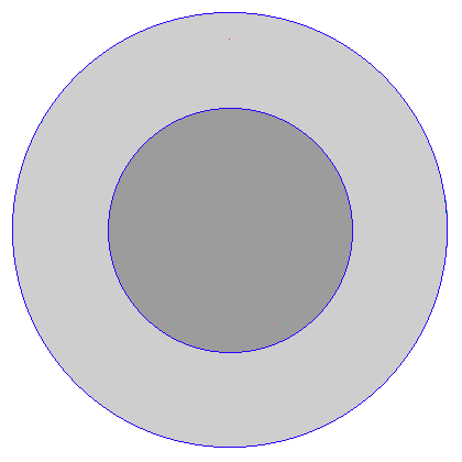
The overall structure of the Earth. |
Seismic tomography is a method of using seismic signals to map the earth's interior in three dimensions.
Return to 296-202 Visuals
Index
Return to Professor Dutch's home page
Created 15 Jan 1997; Last Update
27 September 2005
Not an official UW-Green Bay site