Physical Geology Slides-Volcanoes
Steven Dutch, Natural and Applied Sciences, University of Wisconsin - Green Bay
First-time Visitors: Please visit Site
Map and Disclaimer. Use "Back" to return here.
Cinder Cones
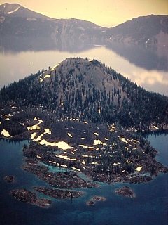 |
Small volcanoes are often just conical piles of loose
rubble called cinder cones with interspersed lava
flows. This cone is Wizard Island in Crater Lake, Oregon. |
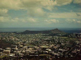 |
This is an unfamiliar view of a famous landmark. Most
people are familiar with just the rightmost side of it.
This is Diamond Head, near Honolulu. It got its name
because 19th century sailors mistook olivine crystals
weathering out of the volcanic rocks for diamonds. |
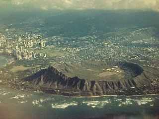 |
Seen from the air, Diamond Head is a broad, low ring.
This is the sort of cinder cone that forms from shallow
submarine eruptions; the eruption spends most of its
energy sloshing water around and the water deposits the
fragmentary debris in a ring around the vent. |
Shield Volcanoes
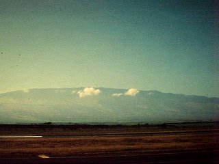 |
Shield volcanoes, like Haleakala, on the island of
Maui, Hawaii, erupt basalt, a very fluid lava. They build
immense, broad domes with gentle slopes. The foreground
is nearly at sea level; the summit of the volcano is over
10,000 feet. Only the central third of the volcano is
shown, and there's another 18,000 feet of it below sea
level. Shield volcanoes are the largest volcanoes by any
measure; height, volume, mass, or diameter. |
Stratovolcanoes
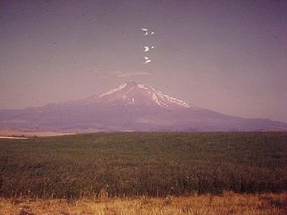 |
Mount Shasta, in northern California, is a very
typical stratovolcano. The scale in this picture is very
similar to the preceding picture; the valley is at about
4,000 feet and the summit is at 14,000 feet.
Stratovolcanoes erupt more viscous lava than shield
volcanoes, and there is more fragmentary material because
of the more violent eruptions. The cones tend to be
smaller and steeper than shield volcanoes, though still
pretty impressive. Note the rounded hills just visible in
the middle distance. We'll see them from a different
vantage point in the next picture. By the way, what are
the v-shaped UFO's above the summit? They're not clouds -
a small real cloud is also visible. |
Answer: they are probably static electricity marks. It was a
very hot, dry day when the picture was taken. Winding film under
such conditions sometimes generates static electricity, tiny
lightning bolts inside the camera.
Collapsing Volcanoes
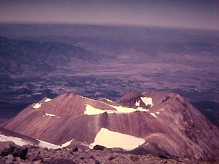 |
This is taken from the summit of Mount Shasta,
looking toward the place from which the previous photo
was taken. Very old volcanoes frequently find it easier
to break through the side of the cone, building a new
vent often called a parasitic cone. Shasta's
parasitic cone is called Shastina. At 12,000 feet it
would be a major Cascade Range summit in its own right;
it just looks small compared to Mount Shasta. (It's not
obvious in the preceding picture because of the lighting
and because it's directly in front of Mount Shasta). |
Shastina has a well-formed crater, indicating it's been active
recently. There is a possible report of an eruption of Shasta or
Shastina in 1786 seen by a ship off the coast.
Note the rounded hills beyond Shastina. After Mount Saint
Helens collapsed in 1980, geologists realized how easily
stratovolcanoes can collapse and rapidly turned up other cases.
The hills had been interpreted as old lava flows covered by
glacial deposits, but are now considered to be the relics of a
great collapse of Mount Shasta about 300,000 years ago. It is
probably no accident that Shastina formed in the collapsed sector,
since it would be very easy for lava to reach the surface there.
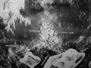 |
Volcanoes, despite their impressive size, are poorly-consolidated
piles of lava flows interspersed with loose debris. In
addition, they eat themselves away from within as acidic
fluids weaken the rocks. Even shield volcanoes can
collapse. More than 50 huge submarine landslides are
recognized around Hawaii. They show up as bright in these
sonar images. In sonar and radar images, bright means
rough, since signals are reflected back at all angles.
Smooth areas show up as dark since signals mostly bounce
away from the source. |
Calderas
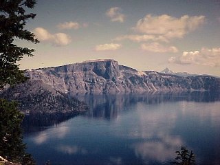 |
Crater Lake, in Oregon, marks a different sort of
volcanic collapse, a caldera. About 6,000 years
ago, a huge eruption blasted out so much material that
the volcano could no longer support its own weight and
caved in. The pre-eruption volcano, called Mount Mazama,
was probably about 12,000 feet high. It was high enough
to support glaciers, because glacial deposits are found
beneath Llao Rock, the cliff on the left side. The cliff
actually marks a former glacial valley filled by a lava
flow that also spread out on either side of the valley. |
Although only six miles across, Crater Lake is 1,932 feet deep
just outside the picture to the right. It is the deepest lake in
the United States and the second-deepest in North America (Great
Slave Lake in Canada is deeper). Wizard Island is visible to the
left, but there are two more volcanoes beneath the surface of the
lake. The lake has no outlet but drains by seepage through the
walls.
Interestingly, the Indian legends about Crater Lake tell of a
great war between Llao, who lived in Crater Lake, and an evil god
Skell, who lived in Mount Shasta. The war devastated the
countryside with fire. Is this an oral tradition going back to
the actual eruption? Is it a story made up by people who were
smart enough to figure things out long afterward?
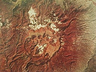 |
The largest caldera in the United States is little-known
except to geologists: the Jemez Caldera in northern New
Mexico. It should be a national park but has long been
private ranch land and closed to the public. In a
excellent display of corporate citizenship, the owners
offered the Federal government the right of first
purchase. The deal nearly collapsed when the Federal
government violated an agreement to keep the terms of the
purchase secret, but was finally concluded. The city of
Los Alamos is located on the eastern rim of the caldera,
a site chosen precisely because of its limited access. |
Volcanic Hazards in the U.S.
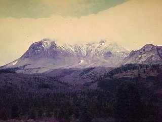 |
Until Mount Saint Helens erupted in 1980, this was
the most recently-active volcano in the continental
United States. Mount Lassen, California is the
southernmost major peak in the Cascade Range and erupted
in 1914-17. Although the photo is taken in August, new
snow dusts the summit. Mount Lassen is really a mass of
overlapping viscous lava flows called lava domes.
The crags in the right middle distance are another lava
dome. The lave emerges as an almost solid pasty mass and
does not flow very far. |
Because of copyright restrictions, the best-known images of
the 1980 eruption of Mount Saint Helens are not reproduced here.
Refer to a site specifically about the eruption to access those
images.
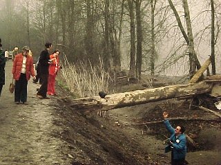 |
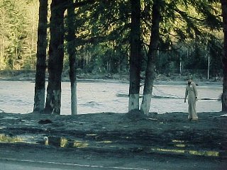
A tree carried downriver by the Mount Saint Helens
mudflow. |
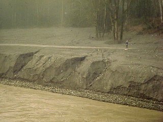 |
Mudflow deposits, actually more like very coarse sand
than mud. The channel was dredged by the Army Corps of
Engineers to prevent flooding. |
 |
These trees were partially buried by a Mount Saint
Helens mudflow. The mudflow compacted after it stopped
moving. The marks on the trees show the original depth of
the mudflow. |
 |
Mount Saint Helens as it appeared from the northwest
in December, 1980. The view is diagonally across the
amphitheater. Note the volcanic gases above the summit. |
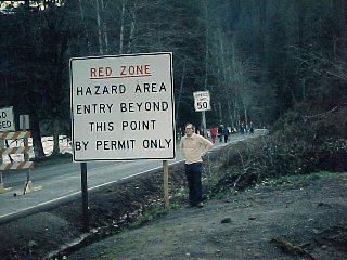 |
Risking life and limb in the red zone of Mount Saint
Helens, the effect only slightly ruined by the people
walking up the road beyond the sign. The red zone has
since been abolished and the road to within a few miles
of the crater is now open. |
|
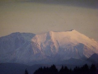
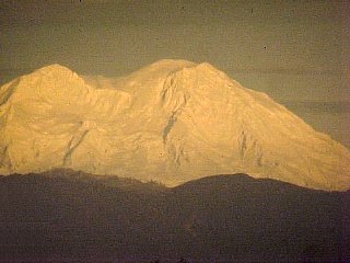
The highest summit of Mount Rainier is a smooth
volcanic cone but the rest of the mountain is rugged. In
fact, the summit of Mount Rainier collapsed about 6,000
years ago. If we extend the remains of the volcano upward,
the original height would have been perhaps 16,000 feet
instead of the present 14,400. Suburbs of Olympia and
Tacoma are built on former mudflow deposits from Mount
Rainier. |
Vesuvius and Pompeii
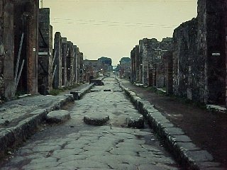 |
Pompeii, buried by Mount Vesuvius in 79 A.D. |
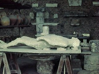 |
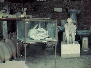
Victims of the eruption were buried in the ash, which
hardened around them. The bodies decayed but the cavity
remained. The cavities are filled with plaster to reveal
even such details as clothing and facial expressions. |
 |
Of the 20,000 people estimated to have lived in
Pompeii, only a couple of thousand bodies were found,
leading most historians and scientists to assume the
eruption was fairly non-violent. That picture changed
dramatically in the 1980's. |
 |
The lowest deposit consists of popcorn-like pumice,
which would not have been very dangerous. The two upper
layers are finer-grained and contain cross-bedding,
indicative of turbulent flow. The brick protruding from
one layer tells the story: a violent ash flow powerful
enough to fling bricks. The eruption was much more lethal
than anyone had previously surmised. |
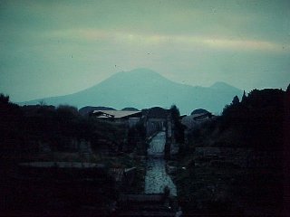 |
The high peak is the present summit of Vesuvius (4800
feet). To the right is part of Monte Somma, a ring of
ridges that surrounds most of Vesuvius. Long thought to
be prehistoric, Monte Somma now seems to be the remains
of Vesuvius after the 79 A.D. eruption. Roman paintings
of Vesuvius show only a single cone, without a hint of
Monte Somma. Also, drawings and paintings of medieval and
Renaissance eruptions of Vesuvius, without exception,
show the summit of Vesuivius lower than Monte
Somma. |
 |
The present crater of Vesuvius. The last major
eruption of Vesuvius was in 1944 (as if Italy didn't have
enough problems then!). Before then, the crater was
shallow with a small, constantly fuming cone in the
center. The white band about 2/3 of the way up the
picture marks the pre-1944 crater floor. |
Intrusions
 |
The cliff is a nice example of a sill, a sheet
of magma intruded between rock layers. The sill and the
surrounding layers tilt to the right. In the background
is the city of Edinburgh, Scotland. This same view is
visible in the background in one scene in the film Chariots
of Fire. |
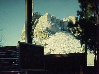 |
Mount Rushmore was picked for the sculpture because
of its granite, but the granite is actually a relatively
thin lens on the top of the mountain. Beneath Washington's
lapel, the much more roughly textured rocks are
metamorphic rocks. A thick dike of granite, one of the
feeders of the pod of granite on top of the peak, can be
seen cutting through the metamorphic rocks. |
Return to Physical
Geology Notes Index
Return to Professor Dutch's Home Page
Created 13 July 1998, Last Update 17 August 1998
Not an official UW Green Bay site