Raster Formats
The format of a raster determines how the cells are stored inside it. Many raster formats have been developed over the years to support specialized uses; some offer high data compression, some handle color better than others, and some are designed specifically to store geographic data. ArcGIS supports over 35 raster formats. Some of the most common formats you'll see are the ESRI Grid and various image formats such as the graphics interchange format (GIF), ERDAS IMAGINE (IMG), tag image file format (TIFF) and Joint Photographic Experts Group (JPEG).
Raster Datasets
A raster dataset is simply a single raster, like land cover for your study area. The term raster dataset refers to any ArcGIS-supported raster format. The raster datasets you've worked with so far in this course have been in a variety of formats, including ESRI Grid, ERDAS IMAGINE, and JPEG.Sometimes a raster dataset is created from multiple rasters. Regardless of how many rasters were used to create it, a raster dataset is a single raster and has only one metadata file. You created a raster dataset in the previous exercise when you mosaiced the DRG into one single file before clipping.
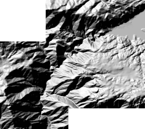 |
| In this raster dataset a single, seamless raster was created from two contiguous rasters with the same properties that were mosaicked together. When a raster dataset is created from more than one raster, the overlapping areas of the input rasters are merged. |
You'll probably find it preferable to use raster datasets (as opposed to raster catalogs) when you want to:
- Use the rasters in a GIS analysis
- Manage a single raster
Although a raster dataset can be stored anywhere, you will find that storing your raster datasets in a geodatabase facilitates data management. You can move the geodatabase anywhere and all of the data inside it moves too—the geodatabase acts as a portable storage container. When raster datasets are stored in a personal geodatabase they are converted to a common, compressed format. The personal geodatabase does not store the original raster data. (That's because rasters can be very large, and there is a 2 GB limitation to the geodatabase.) Instead, ArcGIS creates and stores an ERDAS IMAGINE file (IMG) which references the original raster. The IMG files are stored in an associated "hidden" folder with the same name as the geodatabase and stored within the same folder the geodatabase is stored in. If you move the geodatabase, the folder with the IMG files moves with it.
Raster Catalog
A raster catalog is a collection of individual raster datasets, like an archive of aerial photographs for your study area. A raster catalog is a table that can be viewed just like any other table in ArcCatalog. In a raster catalog, each row in the table represents a raster dataset.While raster catalogs are most often used to display multiple contiguous raster datasets without having to mosaic them into one large dataset, raster datasets in a raster catalog may be noncontiguous, stored in different formats, or have different cell sizes. However, in order to view them together, all the rasters in a catalog must have the same spatial reference.
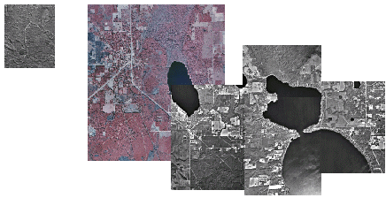 |
| The rasters in this raster catalog are not contiguous and are in different formats. However, they have the same coordinate system and geographic extent. |
You may choose to group your raster datasets into a raster catalog for any of the following reasons:
- You want to create an archive of your imagery.
- You need to preserve the metadata associated with each raster dataset.
- The extents of the raster datasets partially overlap, and you want to preserve the common areas.
- The extents of the raster datasets overlap completely and are part of a time series.
- You do not need to see the entire area at one time. (At smaller scales, raster catalogs display a wire frame, not the raster.)
Advantages of storing raster catalogs in a personal geodatabase include the following:
- Your data is organized in a single storage container.
- You have a choice of making your raster catalogs "managed" or "unmanaged" (described below).
When you create a raster catalog inside a geodatabase, you can choose to have the geodatabase manage it. The geodatabase does this in the same way it manages a raster dataset: it creates ERDAS IMAGINE (IMG) files for each input raster and stores them in a folder with the same name as the geodatabase. When the geodatabase is moved, the folder is also moved.
You can also specify that the raster catalog be unmanaged, in which case the raster is not converted; the catalog just stores the path to the source raster dataset. This facilitates quick catalog creation and easy prototyping of management solutio
Next