Raster Formats
For data management purposes, it's important to know that a raster can be made up of multiple files. These files may include the raster's spatial information including the georeferencing information (cell size, rotation information and origin coordinates), and coordinate system information (the projection, datum, units, etc). You'll learn about georeferencing in the next topic.In some raster formats that are supported by ArcGIS, the georeferencing information is stored internally in the image, while other formats store this information externally in a text file, such as a "world file."
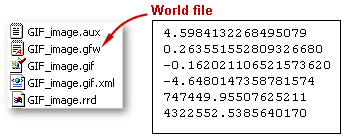 |
| This GIF image's world file stores the raster's georeferencing information. |
Many raster formats were not created specifically for storing spatial information. In this case and for any format, ArcGIS may create an external auxiliary file (AUX) that stores the spatial information.
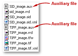 |
| In this example, ArcGIS created an AUX file for the SID and another one for the TIFF raster formats. |
Because rasters store their information in many different files, the best way to manage your raster data is to use ArcCatalog. ArcCatalog ensures that when you copy or move a raster, all the files that are associated with it are also copied or moved, and no information is lost.
You'll probably find it preferable to use raster datasets (as opposed to raster catalogs) when you want to:
- Use the rasters in a GIS analysis
- Manage a single raster
Although a raster dataset can be stored anywhere, you will find that storing your raster datasets in a geodatabase facilitates data management. You can move the geodatabase anywhere and all of the data inside it moves too—the geodatabase acts as a portable storage container. When raster datasets are stored in a personal geodatabase they are converted to a common, compressed format. The personal geodatabase does not store the original raster data. (That's because rasters can be very large, and there is a 2 GB limitation to the geodatabase.) Instead, ArcGIS creates and stores an ERDAS IMAGINE file (IMG) which references the original raster. The IMG files are stored in an associated "hidden" folder with the same name as the geodatabase and stored within the same folder the geodatabase is stored in. If you move the geodatabase, the folder with the IMG files moves with it.
<<Last Next >>